Table of Contents
Introduction
This is the longest trek I've taken with BSA Troop 31, and probably the most memorable. If you haven't read my Treks page, I reccommend it. This is the description of the hike that we ended up doing; it would be easy to trim two days off of it (and make two layover days). I highly recommend this trail for those interested.
Notes: Bear canisters are required to be carried in this area; the only bear I've seen in the wild has been on this trail. Buy or rent canisters at REI or Any Mountain, or rent them from the forest service.
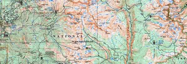
Here's a map of the High Sierra Trail (HST); click on it to get a big one:
Day 1: Crescent Meadow to Nine Mile Creek
 |
The first day of the trek, we packed up our stuff at the trailhead. We had several people just hiking in a day or two with us, so they would return to Crescent Meadow and drive the cars back. Our first campsite was next to a river, but it was steep and thus far from the water source. |
Day 2: Nine Mile Creek to Bearpaw Meadow
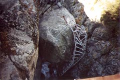 |
This day was a relatively straightforward day. While passing through Buck Canyon, one of our party called out: he heard a bear nearby. The bear continued up the canyon, and left our hiker alone. This is the only time I've seen a bear in the wild, so I'd believe that they have serious bear problems at Bearpaw Meadow. Right after Bearpaw Meadow, there was a new bridge spanning a deep narrow canyon. The old bridge can be seen in the crevice when looking down from the new (stronger) bridge.
|
Day 3: Bearpaw Meadow to Hamilton Lake
The next day, we planned to pass Hamilton Lake, cross Kaweah Gap and camp in the Big Arroyo.
However, when we reached Hamilton Lakes, the weather was worsening and one member had some minor medical problems. After lunch, that member started hiking back (with two others).
After lunch, Kaweah Gap was covered in clouds and it started raining with thunder in the distance.
One of our hiking group went ahead to see if the trail was passable, but said that it was too exposed for the weather.
The storm passed over the narrow valley around Hamilton Lake.
We had experienced thunderstorms the previous two afternoons, but nothing this bad.
It was also a bit disconcerning that every other tree in the valley had distinctive lightning damage on it. In fact, we pitched our tent next to a short tree with distinctive lightning scars.
The storm finally passed with no damage done; the valley's walls were covered with many little waterfalls. It was quite beautiful.
|
 |
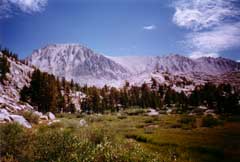
Day 4: Hamilton Lake to Big Arroyo Junction
The next morning was sunny, a relief from the previous days' storms. In fact, the rest of the 11 day trip had perfect weather. This is a good thing: we almost turned around because of the weather.
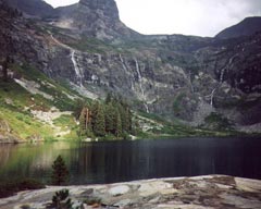
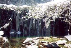
The first mile or two is a strenuous ascent to Kaweah Gap. A few hundred yards before the gap is the beautiful Precipice Lake (right). This lake is featured in Ansel Adam's Frozen Lake and Cliff. The rocks on the lake to the left of this photo are in the exact same arrangement as in Adam's photograph, over 50 years ago. The water is ice-cold (are you surprised?).
The hike down from Kaweah Gap is easy, and the several miles to the Big Arroyo Junction go quickly.
|
 |
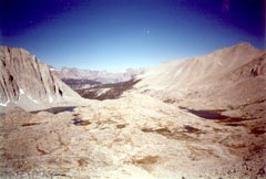
Day 5: Big Arroyo Junction to Moraine Lake
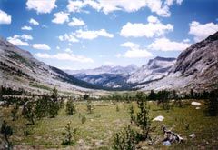 |
The next day consisted of about five miles of gradual uphill to reach Moraine Lake. We chose the northmost (indirect) trail to Moraine Lake, because a ranger said there was a recent fire there and the burnt trees would be interesting to see.
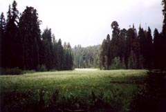
Moraine Lake is pretty, and the meadow nearby is a great place to spot wildlife (we saw plenty of deer; i'm sure a bear or two have been there before.
|
Day 6: Moraine Lake to Kern Hot Springs
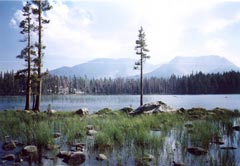 |
After leaving Moraine Lake (left) in the morning, we headed downhill into Kern Canyon. This is one of the longest (especially considering aspect ratio) canyons in the Sierras, and there are some excellent views from its walls.
The trail once we reached the canyon bottom was new and made of largish gravel (about 2 inches). This made for hard going, but we made it to Kern hot springs in time for a swim.
Kern hot springs is fed by volcanic activity in the area. Hot water bubbles up into small ponds saturated with algae (and probably bacteria). The park made a concrete bathtub (complete with stoppers) large enough to fit 4 people tightly. It is refreshing (for young people) to go between the river (cold) and the hot tub (warm).
|
Day 7: Kern Hot Springs to Junction Meadow
|
This stretch is a somewhat long (7 ish miles) gradual uphill climb up the river valley. However, it is very easy, and we did it without stopping, even starting after lunch. At the end of the day, we stopped next to the river, right where the trail leaves the river.
|
 |
Day 8: Junction Meadow to Crabtree Meadow
This day is all uphill. The climb out of the valley is moderate, but gets tedious. There are some excellent views of Kern Canyon from the first mile or two, then the views become more restrictive.
Crabtree Meadow is plesant, although often crouded. You may get the chance to talk with other hikers, but like Bearpaw Meadow, there is a bear problem here. Bearpaw Meadow also has a nice view of the backside of Mount Whitney (right; later on the trail).
|
 |
Day 9: Crabtree Meadow to Guitar Lake
 |
A short uphill hike from Crabtree Meadow to Guitar Lakes is almost a layover day, and is a good rest for the long, strenuous day ahead. Guitar Lake is above tree level, and gets cold at night. When we were there, marmots lived in the rocks and ran around looking for your food. You could also swim in guitar lake, but it's cold. The outlet of the lake looks out over the vast valley that we've spent several days in.
|
Day 10: Guitar Lake to Outpost Camp (including Mount Whitney)
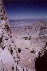 |
This is the climax day of the trip. Starting at Guitar Lake, you hike up several thousand feet nonstop, coming to the intersection between this trail (the John Muir trail) and the route to the top. We dropped our packs here and took the more relaxing uphill climb to the top.
This segment was the coldest of any, by nearly 30 degrees. Take a note of this when choosing your clothes in the morning.
The path to the top goes along the edge of a ridge, with plenty of opportunities to look east towards Lone Pine (and down many thousands of feet).
The top is very wide, you can take your picture next to the sign at the summit, or visit the cabin up there (and sign your name in the book). There is a warning sign on the cabin stating that you shouldn't be on the top in a lightning storm -- you're definitely the highest point around.
The way down to outpost camp is long and steeply downhill. The upper part of the trail has some ice on it, even in early August. Since you have now left Sequoia National Park, the trails aren't nearly as nice, and the downhill going may be difficult.
|
Day 11: Outpost Camp to Whitney Portal
Outpost Camp is only two or three miles from the Whitney Portal trailhead. It's a decent place to stay before making the final trip out of the mountains (to a well-deserved shower).
The final hike is easy, and you will see many people starting to climb the mountain, hoping to make it to the top in a day. If you made it this far, you'll probably be laughing at them, knowing they have no chance to make it.
If you do actually plan to do it this way, you should make it to outpost camp before it becomes light. Also, hit up the gym for weeks before. Note that permits to climb Whitney from this side are hard to get, so apply early.
At Whitney Portal, meet whoever's driving you home, and drive across movie flats to Lone Pine. Lone Pine is a classic old-looking town, and really hot in the summer. We showered in the back of a barber's place there, for a small fee. You (and especially the poor soul who will drive you home) will appreciate you taking a shower here.
|